Google Earth enters fourth dimension, highlights humanity’s heavy hand
Ars Technica » Scientific Method 2013-05-09
Roughly four years ago, Google engineers started working with the US Geological Survey to create what it's now calling Google Earth Engine. Thanks to NASA satellite imagery obtained as part of the Landsat program, the USGS has decades of historic images of the Earth from space, totaling somewhere in the neighborhood of 900TB of data. Google has now combed through these pictures, finding a series of consecutive images that collectively cover much of the planet's land surface. All of the images were chosen specifically for being cloud-free and having good lighting conditions.
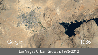
To highlight some of the more dramatic changes, Google has made a few time lapse images of specific sites. The human touch is explicit in images like the deforestation of Brazil and the sprouting of palm-shaped islands off Dubai. But it's also present in the vanishing of the Aral Sea due to the diversion of its sources and the shrinking of Alaska's Columbia Glacier, which has been driven into a dramatic retreat by climate change.
So far, there are only eight image sets available, with no word on when we might expect further time lapses to appear. Because this is Google Earth, however, you can zoom and pan to any area of the globe you want. By centering on Lower Manhattan, it's possible to get a hint of the changes going on at the World Trade center site, and the greening of the new Brooklyn waterfront park is visible across the river.
Read 1 remaining paragraphs | Comments