Last transmitter dies, finalizing retirement for ocean-sensing satellite
Ars Technica » Scientific Method 2013-07-03
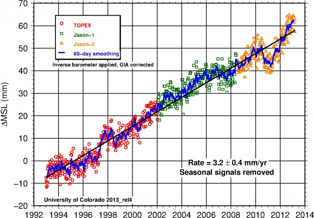
If you have ever seen the graph displayed above, you've admired the work of the Jason satellite. Jason—along with its predecessor TOPEX, and its successor Jason-2—has been tracking the surface of the ocean level for more than two decades now. The data collected reveals regional and short-term changes in sea level, but the key finding is that the global ocean level has been rising at a rate of over 3mm/year due to a combination of melting glaciers and expansion driven by the increased heat absorbed by the oceans.
Through careful planning with the satellites, NASA and its international partners have arranged it so that each orbiter has overlapped with its predecessor for a couple of years. This allows their instruments to be calibrated against each other, which is essential for creating a continuous record like the one shown above.
By early last year, the Jason-2 satellite was calibrated making the original Jason superfluous. By that time, there were concerns that enough hardware on Jason had failed to leave limited backup options in case something else went wrong. As a result, Jason was shifted to a graveyard orbit and the remaining fuel was vented. But it continued to be used for science, as researchers tracked the shifts in its orbit caused by the unevenness of the Earth's mass. Doing so apparently led to the discovery of a number of sea mounts.
Read 1 remaining paragraphs | Comments