The New Secessionists
Bad Hessian 2013-03-17
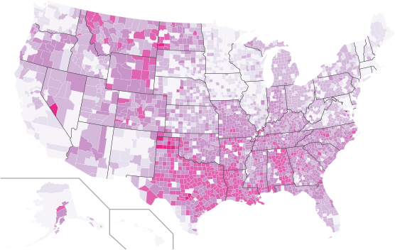
 Signers to White House secession petitions by county. Color based on proportion of residents signing, with darker colors showing higher levels of secession support. Current as of 1am on Thurday, November 15th. Click here for an interactive version.
Since Election Day, more than 60 petitions have been posted on the White House’s website requesting that states be allowed to withdraw from the United States and create their own government. As of November 13, 2012, the following states had active petitions: Alabama, Alaska, Arizona, Arkansas, California, Colorado, Delaware, Florida, Georgia, Idaho, Illinois, Indiana, Kansas, Kentucky, Louisiana, Michigan, Minnesota, Mississippi, Missouri, Montana, Nebraska, Nevada, New Hampshire, New Jersey, New Mexico, New York, North Carolina, North Dakota, Ohio, Oklahoma, Oregon, Pennsylvania, Rhode Island, South Carolina, South Dakota, Tennessee, Texas, Utah, Virginia, Virginias, West Virginia, Wisconsin, and Wyoming.
While petitions are focused on particular states, signers can be from anywhere. In order to show where support for these secession was the strongest, a graduate seminar on collecting and analyzing and data from the web in the UNC Sociology Department downloaded the names and cities of each of the petition signers from the White House website, geocoded each of the locations, and plotted the results.
In total, we collected data on 764,387 signatures. Of these, we identified 270,610 unique combinations of names and places, suggesting that a large number of people were signing more than one petition. Approximately 90%, or 244,001, of these individuals provided valid city locations that we could locate with a US county.
The above graphic shows the distribution of these petition signers across the US. Colors are based proportion of people in each county who signed.
We also looked at the distribution of petition signers by gender. While petition signers did not list their gender, we attempted to match first names with Social Security data on the relative frequency of names by sex. Of the 242,823 respondents with gendered names, 62% had male names and 38% had female names. This 24 point gender gap is twice the size of the gender gap for voters in the 2012 Presidential election.
Tools: Python, Yahoo Geocoding API, and Pete Skomoroch’s remix of Nathan Yau’s county thematic map script.
Neal Caren, Ali Eshraghi, Sarah Gaby, Brandon Gorman, Michael Good, Jonathan Horowitz, Ali Kadivar, Rachel Ramsay, Charles Seguin, and Didem Turkoglu.
Note: This is a repost from the original at http://www.unc.edu/~ncaren/secessionists/ the map at the original site is interactive, but I’ve had trouble adding that functionality here. We reposted to make this Bad Hessians Official. Thanks to the Bad Hessians for having us on as guests.